Every bed you keep, from a raised timber box to a row dug straight into the ground, can sit on one scaled plan at gardenbuddy.au/garden-map/. You do not need a GPS survey to start, just the size of the bed. Here is what it does and how to actually use it.
A minute and a half on what the Garden Map shows and how the drag and tap placement works.
What the Garden Map actually shows
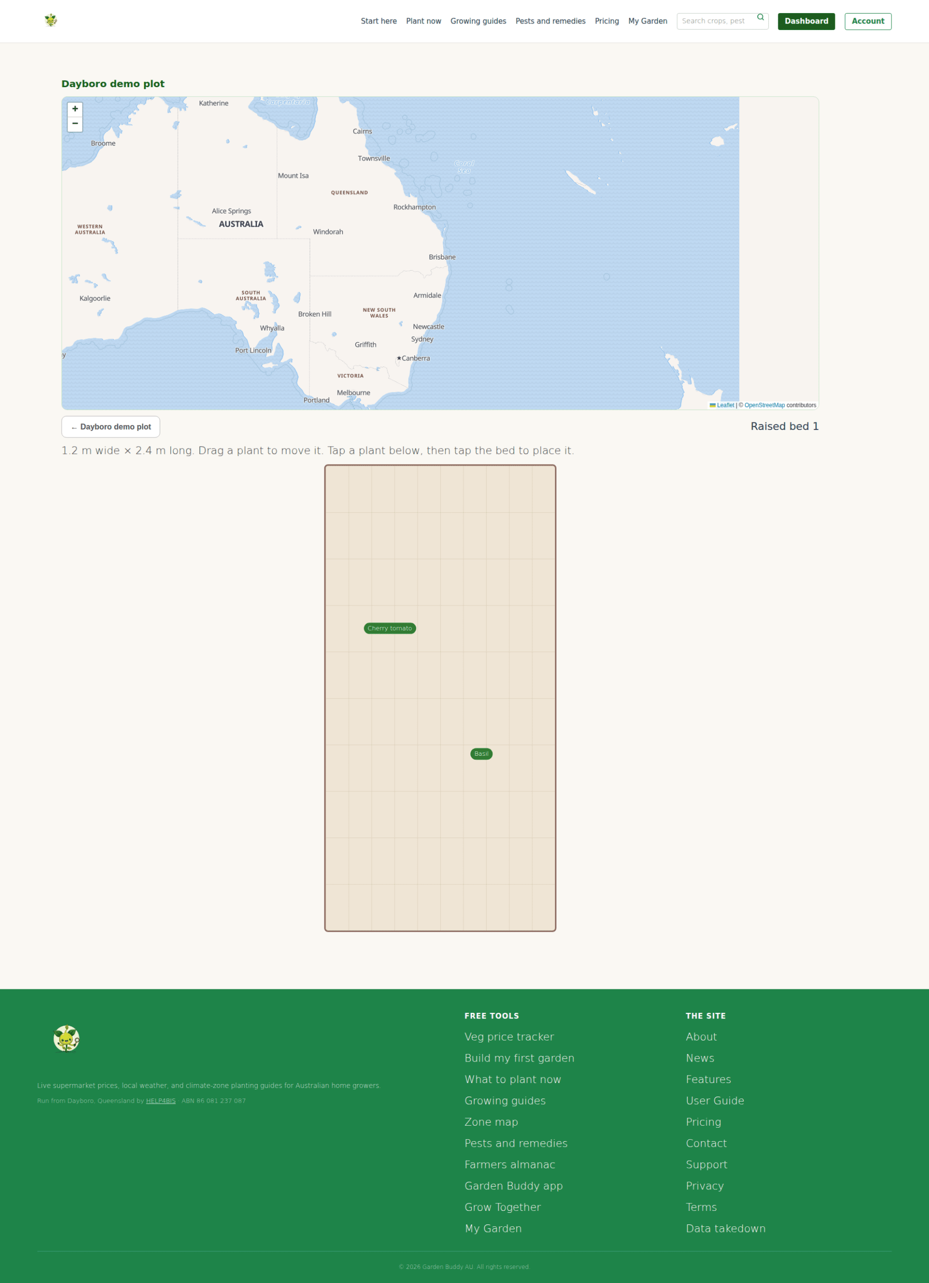
Log in and the Garden Map opens on your own garden, drawn on an OpenStreetMap base (self-hosted map tiles, no third party key needed). Underneath the map sits the working part of the page: your areas, your beds, and the plants you have catalogued. Split a garden into areas if that helps, a veggie patch, an orchard, a greenhouse, areas can even sit inside other areas. Add a bed either by walking its boundary on the map or, far more often, by just typing its width and length in metres. A 1.2 by 2.4 metre raised bed works exactly as well on the plan as a mapped paddock.
Each bed lists how many of its catalogued plants are actually placed on the plan, for example “0 of 3 plants placed”. Open a bed’s plan and it draws that bed as a scaled square, oriented to north if you have set one. Plants waiting to go on sit in a tray underneath. Tap a plant in the tray, then tap the spot in the bed where it grows, and it lands there. Once it is placed, drag it any time to move it to the exact spot, the plan saves the new position as soon as you let go.
Two separate coordinate systems sit behind this, and it is worth knowing the difference. Your garden’s boundary and its areas use real GPS geometry on the map. A plant’s position inside a bed uses only a relative position on that bed’s own plan, a fraction across and a fraction down, never GPS. That is what lets a plant sit in exactly the same spot on the plan whether the bed itself was walked with GPS or just typed in as a width and a length.
Why it matters
A written list of “tomatoes, basil, silverbeet” tells you what is in a bed. It does not tell you what is next to what, how much room is actually left, or whether this year’s tomato went in the same spot as last year’s, which matters for rotating crops away from the same soil. A scaled plan answers all three at a glance, and it does it without asking you to draw anything by hand or remember a paper sketch that gets left in the shed.
It also matters that the size step comes first and the map step is optional. Plenty of gardeners will never walk a boundary with a phone held out in front of them, and this feature does not require it. Type the width and length of a raised bed and you have a working plan in under a minute. Walking the boundary on the map is there for anyone who wants the extra precision, not a gate you have to get through first.
How to use it
- Start a bed: from your garden map, give the bed a name and, if you know it, a width and length in metres. Facing in degrees is optional. Save, and the bed appears in your list straight away.
- Catalogue what grows in it: add a plant with just a name, and pick which bed it belongs to from the list. Botanical name, photo and quantity are all optional extras, not requirements.
- Place it on the plan: open the bed’s plan, tap the plant in the tray, then tap the spot in the bed. Drag any placed plant later to move it.
- Orient it to north: set north on the garden either by dragging the compass control or, on a phone, using its built in compass, and every bed plan you open after that shows which way is north.
- Map the boundary if you want to: use “Place on map” or “Map boundary” to walk the edge of a bed or area with GPS instead of typing dimensions, useful for an oddly shaped bed a rectangle does not describe well.
Frequently asked questions
Do I need to know my bed’s exact size? No. A rough width and length is enough to get a usable plan. You can always come back and refine it.
How many beds can I map? The free plan includes one bed, enough to try the whole feature honestly. Paid plans lift that limit for anyone growing across more than one bed.
Is this the same as the “Add your first garden bed” guide? No, and it is worth being clear on the difference. That guide covers logging a bed as a simple record, no map or plan involved. The Garden Map is the visual layer on top: the scaled plan, the drag and tap plant placement, and the optional GPS boundary walk.
Is this the app’s Planner tab? No. The GardenBuddy.au app’s Planner tab is its own feature with its own compass and shadow tools. The Garden Map covered here is the website feature at gardenbuddy.au/garden-map/, built separately, with its own bed by bed plan view.
Related features
The Garden Map works best alongside a couple of GardenBuddy.au’s other guides.
- My Garden: the member dashboard the Garden Map opens from, alongside your growing guides and prices.
- Build My First Garden: the three question wizard for working out what to grow before you have a bed mapped at all.
- Grow Together: once your beds are mapped and producing, this is where a surplus harvest goes to a neighbour instead of the compost.
Try it now
Head to Garden Map from your My Garden dashboard, add a bed by its size, and place your first plant on the plan. If you are not a member yet, join GardenBuddy.au free to start.